More than 30,000 homes and businesses are currently without power and there have been hundreds of calls to the State Emergency Service (SES) for assistance over a weekend of wild weather in South Australia.
Key points:
- SA Power Networks says it is working to get power restored to homes, businesses as soon as possible
- SES crews have responded to more than 500 calls for assistance over the weekend
- The BOM says places in the Mounty Lofty Ranges received 75mm of rain overnight
Damaging winds, lightning strikes and record rainfall lashed the state overnight, including metropolitan Adelaide where thousands of people are waking up without electricity.
The Department for education said at least nine public schools and preschools had closed for the day due to power outages.
SA Power Networks’ Paul Roberts told ABC Radio Adelaide they had been worried about the conditions that were forecast and were working to get people’s power restored as soon as they possibly could.
“We’ll get crews out there — obviously we’ve rostered crews to work through from last night,” Mr Roberts said.
“We will be out there in force again today to restore power as soon as we can.”
Loading…
SES state duty officer, Cane Murray, told ABC radio Adelaide they had received more than 500 calls for assistance from this weekend’s weather event alone, with more than 300 of those occurring on Sunday.
“There has been a bit of a sting of a tail from this severe weather system,” Mr Murray said.
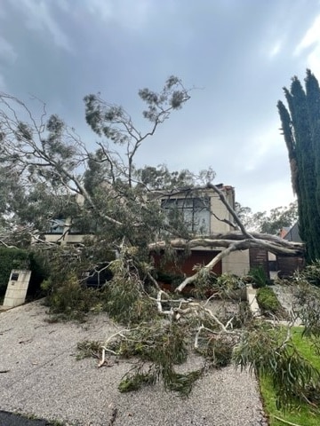
“Most of those have been for trees down — people have had water entering their property through the roof.
“We have up-scaled our preparedness and we are ready for the tail end of this system.”
A severe thunderstorm warning with large hailstones and damaging winds is currently in place for the Flinders, Mid North and parts of Yorke Peninsula districts.
The Eyre Peninsula on the state’s west coast received some of the most rainfall with many towns each recording more than 50 millimetres of rain on Sunday.
Cleve local, Zoe Traeger, said she was amazed when she saw the Yeldulknie weir and reservoir overflow for the first time since January 1993.
“It was an incredible thing to experience … the atmosphere was just amazing,” she said.
Duty forecaster at the Bureau of Meteorology, Belinda House, said there was significant rainfall across the state over the weekend with the Eyre Peninsula the hardest hit.
“In that three-day period up to 9am on Monday we generally saw about 30 to 50mm across lower Eyre Peninsula, but that increased to 50 to 100mm across eastern Eyre Peninsula and the west coast,” she said.
“Cowell picked up 125mm, Cleve 106mm … across to Streaky Bay we saw 76mm there and up to Port Augusta there was 57mm recorded up there.”
Posted , updated