Firefighters and water bombers have been deployed to contain multiple bushfires across South Australia with temperatures already surpassing 40 degrees Celsius in some parts of the state.
Key points:
- The CFS is currently responding to multiple fires across the state
- Catastrophic fire danger ratings are in place for five districts
- Temperatures have passed 40 degrees in areas with dry lightning causing some spot fires
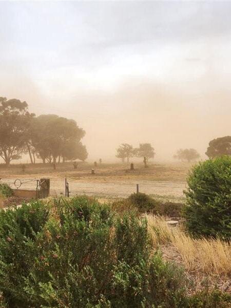
The Country Fire Service (CFS) said that high temperatures, dry thunderstorms and winds up to 100 kilometres per hour are creating the “most significant fire weather risk” SA has faced in recent years.
A warning message has been issued for a series of complex fires in Wirraminna along the Stuart Highway and Tarcoola Road, between Pimba and Glendambo — stretching out to Kingoonya in the state’s outback.
The CFS said roads near those fires currently remain open, but are warning that may change at short notice.
Look back at how ABC readers and other Australians responded to this live moment.
Wondering what this is? Join us next time we’re live and be part of the discussion.
CFS Deputy State Duty Officer Cameron Devey said crews had successfully halted the spread of a grass fire at Melrose in the Mount Remarkable Ranges, but people are being urged to take care with smoke in the area.
Mr Devey said firefighters had battled 17 fires throughout the state so far today, with seven of those still active.
“Our firefighters have been doing a great job on the ground,” he told ABC Radio Adelaide.
“We’re concerned about them and treat them the same way, but we’re not concerned to an extent that we believe we’re going to be out of control at this stage.”
There are currently catastrophic fire conditions forecast for eastern Eyre Peninsula, the Flinders, Mid North, Yorke Peninsula and the Riverland.
Five other SA regions — Northeast Pastoral, West Coast, Mount Lofty Ranges, Murraylands and Upper South East — have an extreme fire danger rating.
Loading…
Emergency Services Minister Joe Szakacs said the CFS has controlled a small fire at Golden Grove in Adelaide’s north-east.
“Thanks to the extraordinary quick response from volunteers on the ground as well as four drops from our bombers, forward advancement of the fire has been arrested.”
Mr Szakacs said cooler weather is not expected until early tomorrow morning.
“We are still in the midst of a very bad day and we are not expecting a relief to come through our northern and eastern regions until around 2am this morning,” he said.
“Now is not the time to be complacent.”
Country Fire Service (CFS) chief officer Brett Loughlin said about 30,000 lightning strikes have been recorded over South Australia.
“Dozens of fires have been put out through the hard work and quick response of firefighters, supported by farm fire units and our aviation assets.”
Flood watches in place across SA
State Emergency Service (SES) deputy chief officer Liz Connell said there are flood watches in place across a large parts of South Australia, including for the Mount Lofty Ranges, Mid North and Eyre Peninsula.
“The heaviest falls will be from about 2am to about 8am and it will continue to be a wet day tomorrow, looking at about 30 to 50mm in the Mount Lofty Ranges,” she said.
She said emergency services are anticipating “significant” rainfall on Sunday.
“On Sunday, we are anticipating we will have significant weather, especially around Eyre Peninsula. Falls of 40 to 80mm and potential local falls in excess of 80mm.”
The Bureau of Meteorology has also issued a severe weather warning for damaging winds with peak gusts of 90 to 100 km/h in those areas of elevated fire risk from late morning, while thunderstorms will likely bring damaging gusts during the afternoon as well.
A wind gust of 93 kilometres per hour was recorded at Cultana, in the north-eastern part of Eyre Peninsula at 9am, with an 80kph wind gust recorded at Coober Pedy at 11:10am.
“Pretty much anything north of about Cleve to Lameroo, we’re likely to see very hot conditions,” senior meteorologist Mark Anolak told ABC Radio Adelaide.
“Coinciding with that change coming through and the risk of dry lighting — so all those elements come together to create a very serious fire weather day for northern parts of the state.”
Temperatures in various locations had already reached 40C by 10:30am.
Roxby Downs, Coober Pedy and Oodnadatta are all climbing into the mid 40s.
Lightning strikes have also been recorded across large parts of the state’s north and west regions.
The federal government has provided aerial firefighting support in the form of a Boeing 737 air tanker, which arrived at RAAF Edinburgh base on Thursday night.
But CFS chief officer Brett Loughlin yesterday warned the community not to rely on firefighters or the aviation assets.
Thousands lose power, schools close
SA Power Networks’s Paul Roberts warned that today’s forecast was “the worst combination possible” for causing power outages and said they were monitoring conditions closely.
More than 20,000 homes and businesses across the state are currently without power — almost half of those are in Adelaide’s northern suburbs.
“We’ll set the networks up in those areas for bushfire conditions and that means the network is set to disconnect as soon as there is a fault,” Mr Roberts told ABC Radio Adelaide.
“We have to be ready to minimise the potential for fire starts and there is always that potential from overhead lines — that means there may be some additional outages then would have been the case otherwise with just a storm.”
The Department for Education has announced that at least 34 public schools and preschools across five regional fire districts will be closed for the day.
Posted , updated