As devastating fires claim scores of homes in the Perth Hills a tropical low is tracking down the north-west coast, a transient Tasman low is brewing in the east and a front is making its way across the Bight.
Key points:
- Although temperatures are expected to ease, dry, windy conditions will continue to make firefighting difficult in south-west WA
- The low that has been tracking along the WA coast is no longer expected to reach cyclone level in the coming days
- A cold front and cut-off low pressure system is expected to bring thunderstorms to the south-east at end the week
Temperatures are expected to drop from the high to low 30s on the firegrounds today, but there is little rain on the way and the Bureau of Meteorology says wind will continue to cause problems over the next few days.
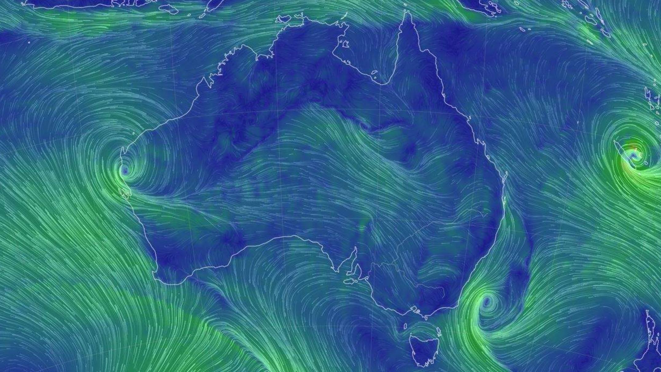
Senior forecaster Jonathan How said a number of wind changes were expected and their unpredictability was likely to be compounded by the low tracking down the West Australian coast.
“The position of that low is going to be very important to the actual fire conditions further south, closer to Perth,” he said.
Mr How said the low could increase the strength of easterly winds, which may in turn fan the flames.
Rain further south would of course be welcome.
“But certainly there is a chance of getting some increased severe weather across the south-west of WA, including Perth.”
The low pressure system has been slowly making its way down the west coast since last week.
Loading
It was forecast to cross the coast and spin up to cyclone-level wind strength, but the latest forecast suggests it will remain a tropical low, at least for the next few days.
As a low it has still produced heavy rain — data is patchy, but it appears there were widespread falls of 50 to 100mm in the 24 hours to 9am on Tuesday.
Wild weather for the south-east
Meanwhile there is a transient Tasman low in the southern Tasman sea, but Mr How says the next system, which is brewing in the Great Australian Bight, is the one worth watching.
A cold front and cut-off low pressure system is expected to develop across the Bight later today and into this evening before the impacts are felt on the mainland from Thursday.
For South Australia, the main influence was expected to be the wind, Mr How said, along with some showers on the coast.
“But then this cold front and system is going to link up with a surface trough over Victoria and New South Wales and Tasmania on Friday,” he said.
Mr How said there was still uncertainty as to where the centre of the low was going to be, but regardless of where the storms form, humidity was expected to be high because of all the tropical moisture being dragged down.
“There is the potential for some fairly widespread severe weather across South Australia, Victoria, Tasmania and southern New South Wales on Thursday through to Saturday.”
Mr How said thunderstorms would be building in Victoria from Thursday, but Friday was likely to be the peak day, particularly across eastern parts of the state.
“We could see some pretty heavy falls and severe thunderstorms right across eastern Victoria, down into Tasmania and also up through southern New South Wales and the ACT,” he said.
In the meantime, monsoonal conditions are continuing to deliver in the tropics.
It will be worth keeping up with the warnings, no matter where you are.