Severe thunderstorms moving across parts of South Australia have dumped rain and hailstones “as big as golf balls”, one local resident says, with the bureau warning of more wild weather overnight and tomorrow.
Key points:
- The bureau has issued a severe thunderstorm warning and strong wind warnings for parts of South Australia
- Hail stones the size of golf balls were reported in Melrose, in the Flinders Ranges
- Meteorologists said heavy rain was expected overnight into tomorrow morning
The Bureau of Meteorology (BOM) has issued a severe thunderstorm warning for parts of the state as well as strong wind warnings for several of the state’s coastal waters.
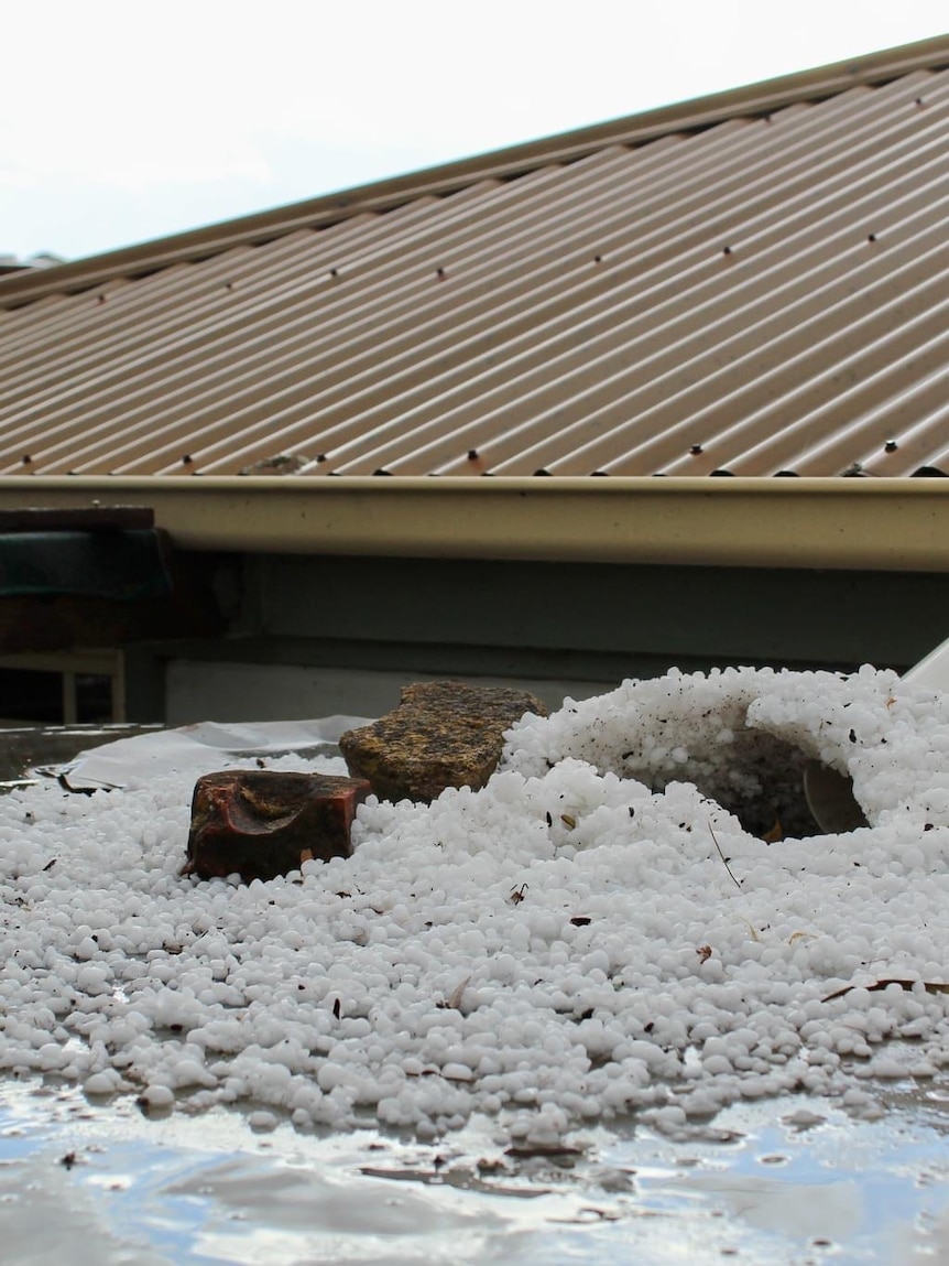
Melrose in the Flinders Ranges is among the towns to have been hit so far, with one local, Kate, telling ABC Regional Drive that large hail pelted the ground about 4pm.
“You couldn’t hear anything on the verandah and it was just so loud — basically, it’s a sea of white. It almost looks like it’s snowed in Melrose,” she said.
“A few people have got kids out making snowmen.”
The long-term Melrose resident said it was the most intense downpour she had experienced in the town.
“They’re a reasonable size — there are some [hailstones] as big as golf balls and some a little bit smaller than that,” she said.
“I haven’t seen anything like this in probably the 20 years I’ve lived in the town.”
Photos from parts of the state show gardens and roofs covered in a layer of hail.
Jenny Horvat from the weather bureau said storms had moved across northern parts of the state, and that heavy rain was expected overnight.
“We are seeing quite a bit of thunderstorm activity around the state at the moment — so just to our north, up around the Mid North and into the Flinders there, and also out to our west around Eyre Peninsula and just making it to the northern parts of Yorke Peninsula,” she said.
She said a trough coming in from the north and an upper low coming across from the west would interact to drive the wild weather, and that possible heavy rainfall was also forecast.
“[It’s] probably more likely in the overnight period as we head into Tuesday morning and maybe some gusty winds at times. We could also see some gusty winds with our gully winds.”
“[We’ll] still keep seeing those showers and thunderstorms persisting overnight across our central districts and moving more broadly into the eastern districts during the afternoon and slowly clearing off later on the day in Tuesday, so it is quite active with those storms.”
The downpours follow recent record-breaking rains in Naracoorte, which received almost 120 millimetres across two days late last week, almost 70mm of which fell in two hours on Friday afternoon.
Posted